In a recent post I noted problematic city/suburb relationships that harm Midwestern cities and metros. Urban problems are on full display for all to see. But there’s a flip side to the poor city/suburb relationship dynamic I spoke about, too. It’s this: some cities and metros are quite good at masking their weaknesses from the eyes of residents and visitors. And their metro perceptions benefit from it.
The Indianapolis Story
Let’s talk about Indianapolis.
Indianapolis is a city that doesn’t get a lot of nationwide coverage on much of anything. Indianapolis might be the archetype for what many people view as a Midwestern city – a decent, midsized city with a good quality of life, affordable, with some of the hallmarks of good urban living but not all. A nice place, but if you’re looking for sizzle, this isn’t it. Somewhere along the way it garnered nicknames like “Naptown” and “India-no-place” and it hasn’t quite shaken the perceptions that come with it.
If there’s anything positive that outsiders recognize about Indianapolis is that it avoided the deep decline experienced by cities like Buffalo, Cleveland and Detroit. In fact, Indianapolis might be better known for adopting a Sun Belt-style growth profile over the last fifty years or so, allowing it to grow in a similar fashion as modestly-sized similar Sun Belt upstarts like Nashville, Jacksonville and Oklahoma City. For people in the Midwest, especially in the Great Lakes, back in the ‘80s and ‘90s it was held up as an example of how to reverse decades of decline and become an urban success story.
But there’s more to Indianapolis’ perceived success than adopting another region’s growth profile.
Indianapolis following World War II was on the same trajectory as many other Midwestern cities. It was troubled by increasing crime, poor school performance, strained race relations and white flight to suburbia. However, Indianapolis took a path that few Midwestern cities did – it pursued a consolidated city-county government that changed its perceptions and trajectory.
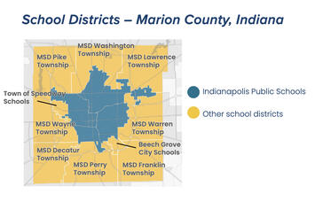
In the late 1960’s, mayor (and later Indiana Senator) Richard Lugar proposed Unigov, or unifying the city of Indianapolis with its suburban communities in Marion County. It was mostly pitched as a way to expand the city’s tax base, putting the city on strong financial footing. It would reduce local government redundancies like police and fire service. However, there were pretty big carve-outs for communities and school districts that chose to remain independent.
The strongest dissenters to Unigov were in Indianapolis’ Black community, which made up about 23 percent of the population at the time. Black concerns centered on the overt omission of the consolidation of suburban school districts with Indianapolis Public Schools,, and Unigov’s reduction of political power for a growing Black community. Unigov supporters said that school district consolidation was a nonstarter that would doom consolidation in the minds of suburban residents, despite the fact that school segregation was already an issue that was vexing the metro area.
The proposal was approved by the Indiana General Assembly in 1969 and went into effect the following year. A legislative act added some 60 percent to Indianapolis’ population (about 475,000 pre-Unigov, 744,000 after) and quintupled its area (71 square miles to 350).
Read the rest of this piece at The Corner Side Yard.
Pete Saunders is a writer and researcher whose work focuses on urbanism and public policy. Pete has been the editor/publisher of the Corner Side Yard, an urbanist blog, since 2012. Pete is also an urban affairs contributor to Forbes Magazine's online platform. Pete's writings have been published widely in traditional and internet media outlets, including the feature article in the December 2018 issue of Planning Magazine. Pete has more than twenty years' experience in planning, economic development, and community development, with stops in the public, private and non-profit sectors. He lives in Chicago.
Photo: Boundaries of Indianapolis Public Schools and other schools districts in Marion County, IN. The IPS boundaries correspond to the city of Indianapolis’ boundaries prior to Unigov city/county consolidation in 1970. Source: indyencyclopedia.org


