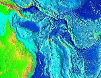
Have you ever tried to visit a South Pacific island near New Caledonia called Sandy Island? A team of Australian scientists attempted just that and found no sign of the supposedly sizeable landmass. Instead, the team from the University of Sydney were greeted by open ocean and nothing more.
In the 21st century, stories like this are rare. Exciting tales of exploration surface from time to time, like Curiosity’s ongoing scientific expedition to Mars. Such occurrences on Earth are now fleeting – it feels like we have discovered almost everything there is to discover. So, maybe it shouldn’t prove too surprising that the Australian scientists actually ‘undiscovered’ some charted and documented territory.
Sandy Island was located somewhere between northern Australia and New Caledonia, albeit closer to the latter. Supposedly, it measured 24 km by 4 km and has been ever-present in maps and publications for the last ten years. Praised continuously for its reliability and accuracy, Google’s mapping program also prominently featured this phantom island. According to statistics released in April 2012, Google Maps is the most popular travel website in the United States.
The entire story seems extremely bizarre – nobody can account for the origin of Sandy Island nor its inclusion on countless maritime charts, maps and online navigation programs. According to Australian news sources, the island would sit within French territorial waters but no trace of it can be found on French government maps.
A marine research vessel named ‘The Southern Surveyor’ was in the region documenting fragments of the Australian continental crust under the Coral Sea. Passing near Sandy Island, navigational charts displayed the considerable depth of 1,400 meters, generating a sense of curiosity amongst the Australian scientists onboard. They investigated further and were quite surprised by what they found…or more specifically, what they did not find. Instead of a white sandy beach lined with palm trees and coconuts, they found the clear undisturbed waters of the Coral Sea.
Dr. Steven Micklethwaite was present on the ship and he shared his views with the Guardian on the expedition to find Sandy Island: “We went upstairs to the bridge and found that the navigation charts the ship uses didn't have it. And so at that point we thought: Well, who do we trust? Do we trust Google Earth or do we trust the navigation charts? This was one of those intriguing questions. It wasn't far outside of our path. We decided to actually sail through the island ... Lo and behold there was nothing! The ocean floor didn't ever get shallower than 1300 metres below the wave-base. There's an island in the middle of nowhere that doesn't actually exist."
Apparently, the captain of the Southern Surveyor was concerned about running aground as his ship approached the phantom island. Once they were sailing through it, however, the entire crew had a laugh at Google’s expense. The search engine giant said it always welcomes feedback on its maps and “continuously explore(s) ways to integrate new information from our users and authoritative partners into Google Maps”.
Experts seemed equally puzzled by Sandy Island’s undiscovery, but most agreed it was probably down to human error or oversight. While some map makers intentionally include phantom streets to avoid copyright violations, maritime charts are usually made as accurate as possible due to the hazards of navigation on the open ocean. Some analysts pointed out that this kind of mistake would never happen in a busy international shipping lane, but due to the immense isolation of the Coral Sea, it escaped attention.
It is quite possible that Sandy Island does exist somewhere nearby – somebody might have just placed it in the wrong location. People have been making maps for thousands of years and many older charts were compiled through the use of watches and longitude measurements. Before that, sailors travelled using the stars, a technique which can still be used today if our GPS systems and maps somehow fail us.
Even though there may be one less island in the world today, the map is constantly changing anyway. New island chains sometimes appear and disappear through volcanic activity, so this certainly won’t be the end of the discovery versus undiscovery topic. Even though the mistake may seem embarrassing for Google, it’s nothing compared to the disastrous debut of Apple’s mapping software which, among other things, was missing Israel’s capital and gave the incorrect address for Dulles Airport in Washington D.C. At the end of the day, a small uninhabited island in the South Pacific is just a tiny speck of dust on a massive picture of the world.
Seamus Murphy grew up in Limerick, Ireland and has since lived in the Netherlands, Germany and Poland. He has a background in public relations and teaching and has become an enthusiastic blogger. Seamus enjoys writing about international affairs, communication, technology and environmental issues at Trenditionist.com. He is a keen fan of traditional Irish music.


Unfortunately the discovery
Oops!! Double post. Sorry...
Unfortunately the discovery
Unfortunately the discovery of the so-called "Sandy Island" failed. Too bad that I had already prepared for a scuba diving activity on this Island. Some of the findings may be correct. It may just an error in Google Map. If that Island is currently present, I am sure that the coral reefs in there are very abundant. Just like in my past Cebu Philippines diving, I was amazed of the fresh and untouched coral reefs in their sea beds. Well, worth a try Dr. Steven Micklethwaite.